Our active research environment connects researchers across disciplines and provides access to geophysical observations systems. Learn more about our research areas.
BSL Research into the Dynamic Earth
Distinct storms in the northern Pacific generate a long-period seismic hum deep into the ocean
Researchers from Berkeley Seismo Lab (Satish Maurya, Taka'aki Taira, and Barbara Romanowicz) present a more clearer picture of seismic hum sources. More than 100 broadband seismic stations along with OBS seismic stations were used to get the high resolution spatio-temporal location of seismic hum sources. The study shows a shorter period (e.g., 70sec) hum is generated along the coast, and longer period hum sources extend into ocean basins. More detail is available at AGU EOS.
Figure caption: Hourly stacked vertical component power spectral density (PSD, in dB) as a function of time for HYS14 (near to coast), AXCC1 (on seamount in Juan de Fuca Ridge ) and MOBB (near to coast in Monterey Bay) stations located at the elevation of -785m, -1528m and -1036m respectively. White dot line indicates the onset of the first appearance of strong energy in OBS due to Cascadia storm. Gray circles indicate earthquakes with magnitude Mw > 5.1.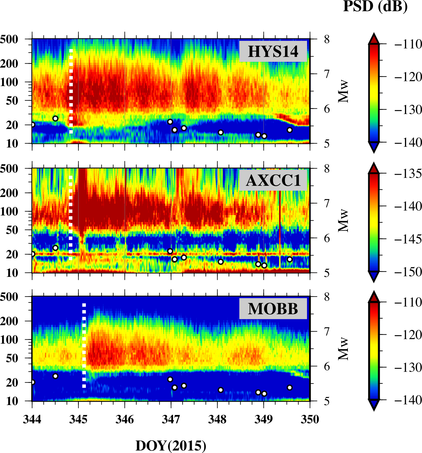
The geodetic signature of slow slip events in the roots of the San Andreas Fault Parkfield segment
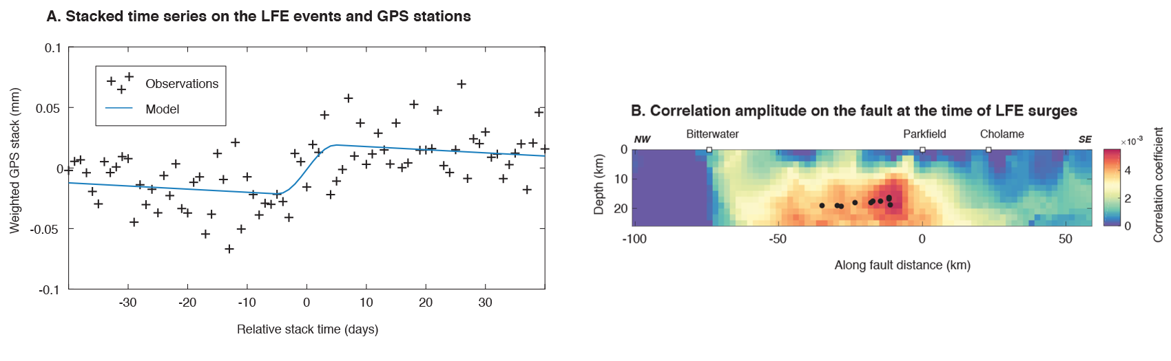
Analyzing slow, aseismic deformation along the San Andreas Fault is a long-lived tradition in the Berkeley Seismological Laboratory. Both seismological observations of repeating earthquakes and tectonic tremors as well as geodetic measurements made by BSL researchers have provided constraints on aseismic slip dynamics on the San Andreas Fault. In a recent study, BSL researchers Baptiste Rousset and Roland Bürgmann and a colleague from the Université Grenoble Alpes in France jointly analyzed GPS time series and tremor catalogs around Parkfield, CA to search for slow slip event signals at the base of the seismogenic zone.
Episodic tremor and accompanying slow slip is mainly observed at the down-dip edge of some subduction seismogenic zones. While tremors present the seismic signature of this phenomena, the majority of accumulated stress is aseismically released and thus the associated fault slip can only be quantified by geodetic observations. On continental strike-slip faults, tremors have been observed in the roots of the Parkfield segment of the San Andreas fault. However, associated transient aseismic slip has never been detected. By using the timing of transient tremor activity and taking advantage of the dense Parkfield-area global positioning system (GPS) network with more than a decade of continuously recorded position time series (Figure 1), BSL researchers are able to detect and characterize the moment of average deep slow slip events (SSEs) on the Parkfield segment. The detection is made using a geodetic matched filter approach in which post-processed GPS time-series stacked over 20 transient events are correlated with synthetic dislocation fault slip models. SSEs with an average moment equivalent to Mw 4.90 ± 0.08 at 16 km depth are releasing ∼ 25% of the loading rate during 5.5% of the interseismic time (Figure 2). The detection of these transient slow slip events located at the northern down-dip edge of the Parkfield locked asperity, at the transition with the creeping section of the San Andreas Fault, provides new constraints on the understanding of the Parkfield seismic cycle.
Read the entire article published in Science Advances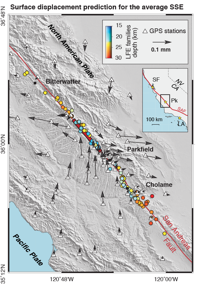
Infragravity Wave Radiation Across the Shelf Break
Berkeley Seismo Lab seismologists Barbara Romanowicz and Taka'aki Taira used Cascadia Array data to model the origin and radiation of infragravity waves in a JGR Oceans paper collaborating with partners in industry. Read the paper at JGR Oceans
From EOS Research Spotlight: On the Origins of Infragravity Waves:
"Waves on the surface of the ocean with long periods (1–5 minutes) and low frequencies (0.005–0.05 hertz) are called infragravity waves. These features, which appear to originate from physical interactions between wind-driven waves near coastlines, play an important role in sediment transport, coastal erosion, and other nearshore processes..."
Read more from EOS Research Spotlight
Research Areas
Seismic Noise: Taka'aki Taira, Michael Manga, and others are studying the speed of seismic waves beneath the Salton Sea to learn more about very shallow earth structure. This new tool is giving us clues to the inner workings of volcanoes and geothermal fields.
Fluids in Geophysical Processes: Why do volcanoes (only sometimes) erupt explosively? How do distant earthquake affect volcanic and geyser eruptions? How do pyroclastic flows interact with water? The Manga group studies geological processes involving fluids, including problems in physical volcanology, hydrogeology, and geomorphology, in an attempt to develop a better quantitative understanding of physical processes operating in the Earth.
InSAR and the Hayward Fault: The Bürgmann group modeled the Hayward and Calaveras Faults using InSAR radar satellite measurements. Results indicate the faults should be treated as a single system with potential to generate events with magnitudes significantly greater that 7, posing a higher seismic hazard than previously considered.
Seismic Sources: The seismic source (Dreger) group focuses on the use of seismic waveform data to investigate seismic sources (tectonic and non-tectonic), wave propagation, and various geophysical inverse problems, as well as developing robust automated procedures to analyze earthquakes as they occur. Current projects include studying induced seismicity at the Louisiana sinkhole and monitoring seismicity and ambient noise at the Geyers geothermal field.
ShakeAlert: ShakeAlert is the earthquake early warning system under construction in the United States. The BSL has been part of this effort since its inception in 2001, and continues to work towards public alerts.
MyShake MyShake is a global smartphone-based seismic network from the Allen group. The goal: provide global earthquake early warning.
Earth's Geodynamo: The Buffet group studies planetary magnetic fields to discover more about the dynamics and evolution of planetary interiors.
Imaging the Upper Mantle: The Romanowicz group's recent work suggests that the formation of mantle plumes, and the hotspots that form islands like Hawaii, is more complex than previously understood.
Alaska: Alaska is the last frontier for Earthscope. As the dense USArray spreads across the state we start to observe the dynamic processes responsible for the region’s earthquakes and volcanoes.
Fluids in Geodynamics: How does the internal structure of the mantle affect the formation and evolution of mantle plumes? Are there compositionally distinct layers at the base of the mantle? and do they influence the formation of plumes? Michael Manga's group studies the role of fluids in geodynamics.
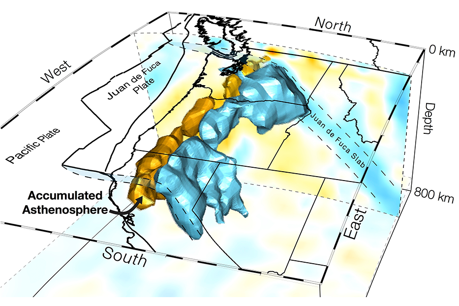
Cascadia: The enigmatic Cascadia Subduction Zone lacks the continuous seismic activity seen at most convergent plate boundaries. The Allen group uses a variety of Earth imaging techniques to understand tectonic processes in the region.
Recent Research


Earthquakes and the Rainfall Cycle
Chris Johnson and Roland Bürgmann's research is featured in the video below.