Seismo Blog
Deep and Strong
Categories: Fiji | Plate Tectonics
August 20, 2018
When on Sunday shortly after noon (local time) a very strong earthquake occurred in the Pacific Ocean about 220 miles east of Fiji's capital Suva, hardly anybody noticed. Only 8 people reported to the website "Did You Feel It?," that they felt some light shaking. A few more people noticed the quake's seismic waves in Pago Pago, the main city in American Samoa more than 500 miles away from the epicenter. But when seismologists calculated the magnitude of this quake, they quickly realized that this undersea temblor was the strongest earthquake so far this year. It had a magnitude of 8.2. Why did hardly anybody feel such a very strong shaker?
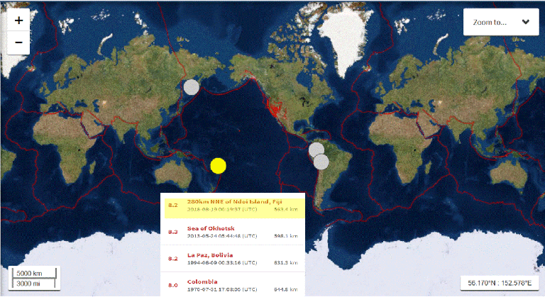
Figure 1: In the last 120 years only four deep focus quakes occurred with magnitudes of 8 or above. Their epicenters are shown by circles on this map. Sunday's quake east of Fiji is marked in yellow.Source: USGS 
The main reason for the light shaking at the Earth’s surface is the location of this quake. Its hypocenter lay deep underground almost 350 miles below the seafloor of the Pacific. That depth is about the same as the distance between San Francisco and Los Angeles. Here in northern California we would certainly feel the seismic waves from a magnitude 8.2 quake down south – and vice versa. But both of these urban areas are inhabited by millions of people each. In contrast the archipelagoes of Fiji, Tonga and Samoa in the South Pacific are very sparsely populated and the rest of the epicentral region is covered by water. Hence, there are many fewer people to feel the shaking of a distant quake, even a strong one.
Sunday's quake was unusual for another reason as well. It was only the fourth deep focus earthquake since 1900 to have a magnitude of 8 or higher. It was only one tenth of a magnitude unit weaker than the current record holder for very deep quakes, an 8.3 temblor which occurred in May 2013 at a depth of 370 miles beneath the Sea of Okhotsk off the coast of the Russian far east.
Such quakes with foci at depths of 200 miles or more inside the Earth are relatively rare and only occur in certain regions of the globe. They are confined to subduction zones where one of the tectonic plates floating on the surface of the Earth dives beneath another and is submerged into the Earth's mantle. Here in California, the tectonic plates slide past each other in a horizontal strike-slip fashion. In other places around the Pacific Rim where there is contact between 2 or more plates, however, one of those plates dives deep into the mantle. Alaska and the Aleutian Islands, Japan, the Philippines, and the South Sea Islands of Fiji, Tonga and Samoa – each has its own subduction zone, where the Pacific Plate dives several hundred miles deep into the Earth.
The Fiji Islands lie on the eastern edge of the Australian plate, which is overriding the Pacific Plate that dives into the mantle beneath it. This collision happens at a high convergence rate, because the Pacific Plate moves westward with about 3 inches per year. As the plate dives into the Earth's mantle, it is bent and mechanical stresses build up. Occasionally, such stresses overcome the strength of the rock in the subducting plate leading to an earthquake. Sunday's quake, a normal faulting event, was the consequence of such stress relief.
However, not all deep focus earthquakes are caused by the stresses generated when a subducted plate is bent, or by a collision with the opposing plate above. Another possible cause of deep events is a volume change associated with phase transitions of certain minerals in the rocks within the diving plate. These changes are similar to the increase in volume when water turns into ice. In the mantle the mineral olivine undergoes a phase transition and becomes spinel. Although chemically identical like water and ice, these two minerals have different densities. Spinel is about 7 percent denser than olivine. Hence, when spinel forms from olivine as a super-weak layer of tiny grains within micro-cracks, these micro-cracks start to link up and there is sudden shearing of the rock. This shearing may be the cause of the unusually deep earthquakes – at least this is how the theory goes. The deepest quake ever measured, a magnitude 7.8 event 420 miles under the Bonin Arc south of Japan seems to have been caused by such a phase transition. (hra159)
BSL Blogging Team: Who we are
Recent Posts
-
: Alerts for the Whole West Coast
-
: Destruction in the Eastern Aegean Sea
-
: An Explosion in Beirut heard all over the Middle East
View Posts By Location
Categories
- Alaska (3)
- Bay Area (24)
- Buildings (3)
- Calaveras (4)
- California (13)
- Central California (4)
- Chile (4)
- Earthquake Early Warning (10)
- Earthquake Faults and Faulting (44)
- Earthquake Science (3)
- Haiti (3)
- Hayward (12)
- Indonesia (4)
- Induced Seismicity (3)
- Instrumentation (18)
- Italy (6)
- Japan (7)
- MOBB (3)
- Mendocino Triple Junction (5)
- Mexico (7)
- Nepal (3)
- North Korea (5)
- Nuclear Test (5)
- Ocean Bottom Seismometer (3)
- Oklahoma (4)
- Plate Tectonics (18)
- Preparedness, Risks, and Hazards (15)
- Salton Sea (3)
- San Andreas Fault (14)
- Seismic Waves (13)
- Seismograms (4)
- ShakeAlert (3)
- Southern California (5)
- Surface Waves (3)
- Today in Earthquake History (20)
- Volcanoes (4)
- subduction (3)