Seismo Blog
Where earthquakes occur in California
Categories: California | Garlock Fault | San Andreas Fault | Earthquake Faults and Faulting
October 3, 2008
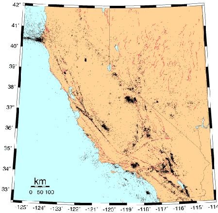
In the same way as earthquakes are neither evenly nor randomly distributed throughout the world (see blog September 29, 2008), California also has a few earthquake zones as well as vast areas which are essentially void of all Earth's tremors. There are actually distinct bands and clusters of seismicity in our state which can be clearly spotted on a map of earthquakes.
The most famous zone of all is, of course, the San Andreas Fault. It snakes almost all the way through the Golden State, from the Salton Sea in the Imperial Valley in the south, to Cape Mendocino in the north. At a first glance it looks as if earthquake foci line up along this zone like pearls on a string. But looking a little bit more closely one finds that the San Andreas Fault is not just one clear thin line but a zone of tectonic movement, which can be up to several dozen miles wide. Sometimes the zone consists of several faults, which parallel each other.

Figure 1: Seismicity and Faults in California (USGS)
The picture gets murkier in the Los Angeles Basin. The reason is that the crust under LA is cracking along dozens of short fault segments, many of them not yet even named by seismologists. The ultimate cause for the earthquakes along the San Andreas system and in the LA basin is the sliding of the Pacific Plate against the North American Plate with a velocity of about 2.5 inches per year.
Where the San Andreas Fault ends in the north, the seismicity fans out into the Pacific Ocean like an elephant's trunk to the west of Cape Mendocino. There the "Mendocino Fracture Zone" takes over the steady slide of the tectonic plates.
Other clear bands of seismicity occur along the Garlock Fault in Southern California's Transverse Ranges, along its continuation through the Owens Valley, and further north along the steep eastern flank of the Sierra Nevada. The earthquakes there are not caused only by the sliding of the plates, but are also a consequence of the slow lifting of the Sierra Nevada, which has occurred during the last several million years.
And last but not least, there is a third class of earthquakes in California. These temblors can be found in clusters around the Geysers along the Sonoma and Lake County border, around Mammoth Lakes east of Yosemite, and to a smaller extent around the Coso Field near Ridgecrest. The causes of these mostly small quakes are remnants of volcanic and geothermal activity, like the restless Long Valley caldera next to Mammoth, which blew up in a gigantic volcanic eruption 760,000 years ago. (hra007)
BSL Blogging Team: Who we are
Recent Posts
-
: Alerts for the Whole West Coast
-
: Destruction in the Eastern Aegean Sea
-
: An Explosion in Beirut heard all over the Middle East
View Posts By Location
Categories
- Alaska (3)
- Bay Area (24)
- Buildings (3)
- Calaveras (4)
- California (13)
- Central California (4)
- Chile (4)
- Earthquake Early Warning (10)
- Earthquake Faults and Faulting (44)
- Earthquake Science (3)
- Haiti (3)
- Hayward (12)
- Indonesia (4)
- Induced Seismicity (3)
- Instrumentation (18)
- Italy (6)
- Japan (7)
- MOBB (3)
- Mendocino Triple Junction (5)
- Mexico (7)
- Nepal (3)
- North Korea (5)
- Nuclear Test (5)
- Ocean Bottom Seismometer (3)
- Oklahoma (4)
- Plate Tectonics (18)
- Preparedness, Risks, and Hazards (15)
- Salton Sea (3)
- San Andreas Fault (14)
- Seismic Waves (13)
- Seismograms (4)
- ShakeAlert (3)
- Southern California (5)
- Surface Waves (3)
- Today in Earthquake History (20)
- Volcanoes (4)
- subduction (3)