Seismo Blog
Earthquakes on Top of the World
Categories: Alaska | Plate Tectonics
August 13, 2018
When on Sunday morning shortly before 7 am local time, the citizens of Fairbanks in Alaska awoke to noticeable ground shaking, many of them thought these seismic waves were coming from the south. After all, most quakes in this seismically hyperactive state take place along the subduction zone near the coast with the Gulf of Alaska. There the Pacific Plate dives under the North American continent, causing some of the strongest quakes ever measured in the United States. The Denali Fault, another source of violent temblors in Alaska, also lies to the south of Fairbanks.
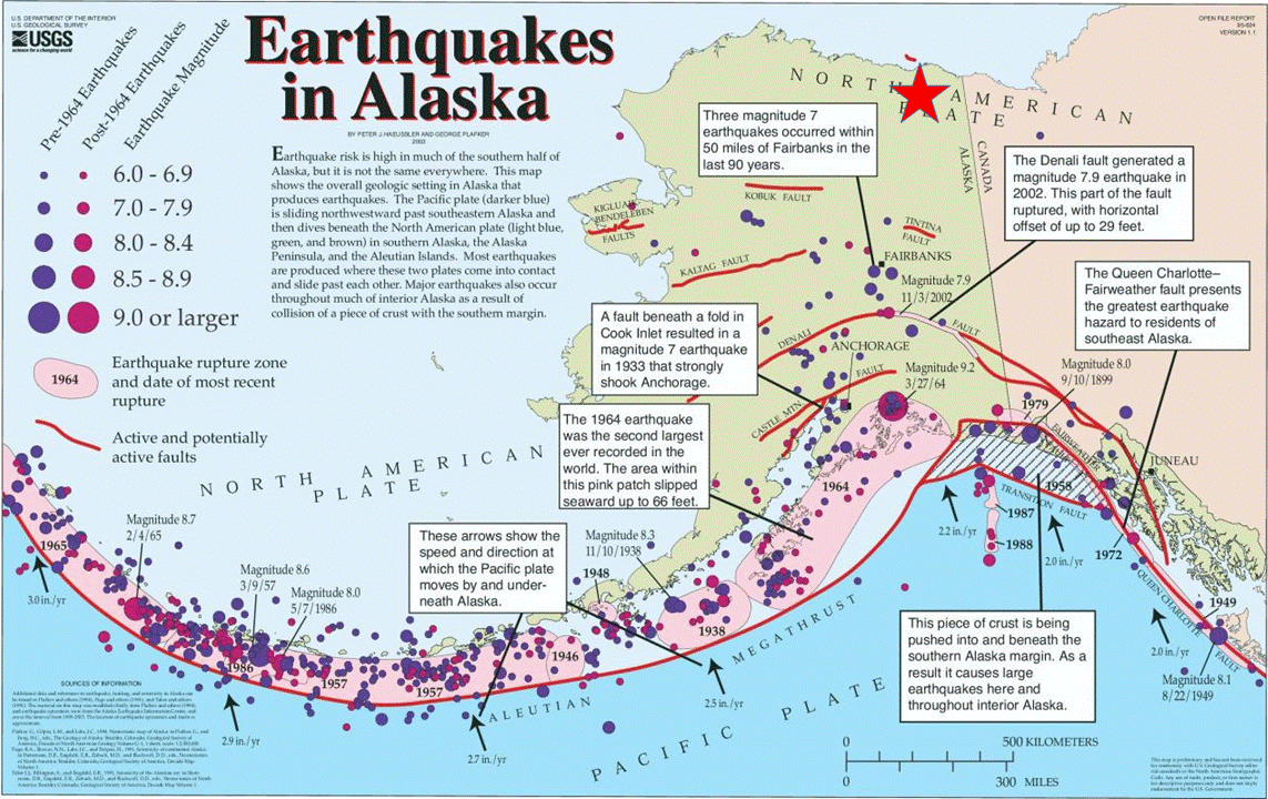
Figure 1: Sunday's 6.4 quake and its many aftershocks (red star) occurred far away from Alaska's typical earthquake area. Source: USGS
But on Sunday morning, neither of these "usual suspects" caused the shaking. Instead, the seismic waves reached Fairbanks from far north of the polar circle. They originated in a magnitude 6.4 quake on the North Slope, about halfway between Prudhoe Bay and Alaska’s border with Canada’s Yukon Territory. This area north of the Brooks Range is better known for its vast remoteness and stark beauty than for strong earthquakes. In fact, Sunday's quake and its 6.0 aftershock a few hours later were the strongest temblors ever recorded in Alaska's frigid far North.
Little is known about the tectonics of the North Slope. Some faults were identified during the offshore exploration for hydrocarbons in Prudhoe Bay and its vicinity. But the foci of this quake and its plentiful aftershocks were located about 25 miles inland from the shores of the Beaufort Sea, which is part of the Arctic Ocean. No seismically active tectonic faults have ever been mapped in the epicentral area and for dozens of miles around it.
That, however, does not mean that the remote area north of the Brooks Range has been free of earthquakes. Quite to the contrary, because since seismic observations began in Alaska in the 1970's, more than 4000 temblors have been recorded – although most of them are very small. The researchers at the Alaska Earthquake Center report that this region has been rattled by a magnitude 5 temblor every eight years or so – but none of the past events has ever come close Sunday’s shakers. Local seismologists hope that these strong quakes can shed some light onto the hitherto unknown tectonics of the area.
Alaska's North Slope is not the only area north of the polar circle where the Earth has been trembling lately. About a month ago, even the North Pole was shaken by a nearby quake. On July 17 a moderate 4.8 temblor happened just 200 miles from the Top of the World. However, this undersea quake occurred on a well known fault system. There the Arctic sea floor is being pushed apart by the slowest midoceanic ridge in the world. The Gakkel Ridge, a continuation of the Mid-Atlantic Ridge, spans the North Polar Ocean almost all the way into the Siberian Arctic. While the two flanks of the spreading feature in the Atlantic Ocean drift away from each other at a rate of a few inches per year, the annual movement of the flanks of the Gakkel Ridge is only about one tenth of an inch. This slow movement is still enough to cause an occasional quake, like the one recorded in mid July. (hra158)
BSL Blogging Team: Who we are
Recent Posts
-
: Alerts for the Whole West Coast
-
: Destruction in the Eastern Aegean Sea
-
: An Explosion in Beirut heard all over the Middle East
View Posts By Location
Categories
- Alaska (3)
- Bay Area (24)
- Buildings (3)
- Calaveras (4)
- California (13)
- California ShakeOut (3)
- Central California (4)
- Chile (4)
- Earthquake Early Warning (10)
- Earthquake Faults and Faulting (44)
- Earthquake Science (3)
- Haiti (3)
- Hayward (12)
- Indonesia (4)
- Induced Seismicity (3)
- Instrumentation (18)
- Italy (6)
- Japan (7)
- MOBB (3)
- Mendocino Triple Junction (5)
- Mexico (7)
- Nepal (3)
- North Korea (5)
- Nuclear Test (5)
- Ocean Bottom Seismometer (3)
- Oklahoma (4)
- Plate Tectonics (18)
- Preparedness, Risks, and Hazards (16)
- Salton Sea (3)
- San Andreas Fault (14)
- Seismic Waves (13)
- Seismograms (4)
- ShakeAlert (3)
- Southern California (5)
- Surface Waves (3)
- Today in Earthquake History (20)
- Volcanoes (4)
- subduction (3)