Seismo Blog
Earthquakes and the Rainfall Cycle
Categories: Central California | Earthquake Faults and Faulting | San Andreas Fault
June 15, 2017
The blogger has had this experience several times while studying the remote San Andreas Fault in Central California east of Paso Robles. In this region the ranches measure tens of thousands of acres in size. During the incredibly hot dog days of summer, we have encountered grumpy old ranch hands who were ready to throw us off their land. But when they learned about the blogger's day job as a seismologist, they often changed their tone: "Feels like earthquake weather today", they grunted, as they turned and left the blogger alone to do his work. Well, of course, we scientists know that the weather plays no role in generating seismic temblors. Neither do the phases of the moon or the alignment of the planets. But according to new research published today by colleagues from the Berkeley Seismological Laboratory (BSL), the host of this blog, these crusty old ranch hands might have a point. Along some California faults, a slight increase in the number of small quakes does indeed occur during mid and late summer. However, Chris Johnson and Roland Bürgmann write in the latest issue of the journal "Science" that this small uptick in the number of micro-earthquakes has nothing to do with the daily weather but more with the long term annual precipitation patterns.
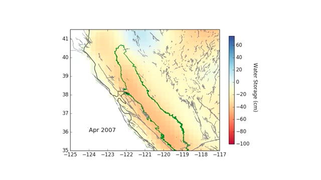
So, where is the connection between seismicity and rainfall? It has to do with two things: the weight of water and the strong seasonality of the rainfall in our Golden State. As this last winter clearly showed, more than ninetyfive percent of all precipitation in California falls between October and May. Much of it accumulates as snow in the Sierra Nevada. In addition, the ground is soaked by all the rain and retains much of it. In fact, the weight of the snow and the ground moisture is so large, that it pushes down the Sierra and its foothills by about half an inch or so. This amount is way too small to be noticed in everyday life. It can, however, be measured with sensitive tools called "geodetic GPS receivers". These instruments function on the same basis as the navigational systems on your smart phone or in your car, but they are much more precise and can measure tiny movements - even the push on the mountains caused by the weight of the water. Such measurements also show that in the summer, when all snow is melted and the ground has dried out, the weight is taken off the Sierras. The mountains rise and the surrounding Earth crust will flex, only to be depressed again by next winter's rain. A similar seasonal up and down can be measured in the Coast Ranges, albeit not nearly as pronounced as in the mountains further east.
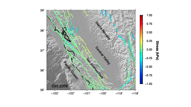
According to the BSL researchers this small annual ying and yang of the mountain movements is enough to change the mechanical forces acting on the earthquake faults in California. In scientific parlance we call such an effect a "stress change" on the fault. Each time such stresses change, there is a chance of earthquakes being generated. By comparing the water load with the number of small quakes over a period of nine years Johnson and Bürgmann found that the stress changes are particularly noticeable in mid and late summer. A slight increase in the number of micro-earthquakes was the consequence.
The goal of this study was not to vindicate or disprove the folklore spread by the California ranch hands. Instead, measuring the cause and effect of stress changes along a fault helps us understand in a little more detail how seismic temblors are generated. The answer to this fundamental question is still a great enigma in earthquake science. (hra141)
The research paper by BSL's Johnson and Bürgmann can be found here:
http://science.sciencemag.org/cgi/doi/10.1126/science.aak9547
BSL Blogging Team: Who we are
Recent Posts
-
: Alerts for the Whole West Coast
-
: Destruction in the Eastern Aegean Sea
-
: An Explosion in Beirut heard all over the Middle East
View Posts By Location
Categories
- Alaska (3)
- Bay Area (24)
- Buildings (3)
- Calaveras (4)
- California (13)
- California ShakeOut (3)
- Central California (4)
- Chile (4)
- Earthquake Early Warning (10)
- Earthquake Faults and Faulting (44)
- Earthquake Science (3)
- Haiti (3)
- Hayward (12)
- Indonesia (4)
- Induced Seismicity (3)
- Instrumentation (18)
- Italy (6)
- Japan (7)
- MOBB (3)
- Mendocino Triple Junction (5)
- Mexico (7)
- Nepal (3)
- North Korea (5)
- Nuclear Test (5)
- Ocean Bottom Seismometer (3)
- Oklahoma (4)
- Plate Tectonics (18)
- Preparedness, Risks, and Hazards (16)
- Salton Sea (3)
- San Andreas Fault (14)
- Seismic Waves (13)
- Seismograms (4)
- ShakeAlert (3)
- Southern California (5)
- Surface Waves (3)
- Today in Earthquake History (20)
- Volcanoes (4)
- subduction (3)