


2012 Annual Report - Research Reports
 From Research Section 5:
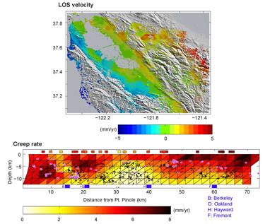
This model of creep, movement on the Hayward Fault with no accompanying earthquake, suggests that the creep rate near the surface is faster along the southern section of the fault. At greater depth, the situation is reversed, with higher rates in the north than in the south. Given the fact that most of the Hayward fault has accumulated a deficit of 30%-90% of its long-term slip budget, we estimate that seismic moment for a Mw ~6.3-6.8 has accumulated since the last big event in 1868.
- Episodic Tremors Highlight Slow Slip Events in Central California
- Searching for Small Deformation Signals in Laser Strainmeter Data Associated with Seismic Tremor in Parkfield
- TremorScope: Imaging the Deep Workings of the San Andreas Fault
- Time-dependent Model of Creep on the Hayward Fault from Joint Inversion of 18 Years of InSAR and Surface Creep Data
- Landslide Risk Assessment (LSRA): GPS Instrumentation and Remote Sensing Study of Slope Movement in the Berkeley Hills, California.
- Investigating Fault Slip and Rheology Along the San Andreas Fault in the San Juan Bautista Region
- Aseismic Slip and Fault Interaction from Repeating Earthquakes in the Loma Prieta Aftershock Zone
- Surface Slip during Large Owens Valley Earthquakes from EarthScope Lidar
- Testing the Temporal Persistence of Slip Rate Along the Little Lake Fault, Eastern California Shear Zone
- Examining the Mechanical Behavior and Evolution of the Southern San Andreas Fault System through Determination of Late Quaternary Slip Rates and Distinct Element Simulations
- Investigating Fault Slip Budget in the Mendocino Triple Junction
- Incipient Faulting near Lake Pillsbury, CA
- Measurements of PBO Borehole Seismometer Orientations
- Spatiotemporal Behaviors in Earthquake Multiplets at the Geysers Geothermal Field, CA
- A systematic analysis of seismic moment tensor for seismicity at The Geysers Geothermal Field, California
- Joint Inversion of Seismic and Geodetic Data for the Source of the 4th March 2010 Mw 6.3 Jia-Shian, SW Taiwan, Earthquake
- Deciphering the Mystery of the Great Indian Ocean Earthquakes
- Source Spectral Variation and Yield Estimation Derived from High Frequency P and S Coda
- Regional Moment Tensor Inversion for Shallow Sources: the Effects of Free-Surface Vanishing Traction
- ShakeAlert: A Unified EEW System for California
- ElarmS Earthquake Early Warning
- Earthquake Early Warning with GPS Data
- GPS Rapid Response to Moderate Earthquakes: A Case Study of the Alum Rock Earthquake
- Using Smartphones to Detect Earthquakes
- Probing the Deep Rheology of Tibet: Constraints from 2008 Mw 7.9 Wenchuan, China Earthquake
- Global Waveform Tomography with the Spectral Element Method: A Second-Generation Upper-Mantle Model
- The DNA12 Seismic Velocity Model
- Trust but Verify: a spot check for the new stratified model of upper mantle anisotropy beneath North America
- 3-D Seismic Velocity Structure of the Hawaii Hotspot from Joint Inversion of Body Wave and Surface Wave Data
- Azimuthal anisotropy in the Pacific upper mantle
- Anisotropic Upper Mantle Shear-wave Structure of East Asia from Waveform Inversion
- An Exceptionally Large ULVZ at the Base of the Mantle near Hawaii
- Do "double SS precursors" mean double discontinuities?
- Inversion of Receiver Functions without Deconvolution
- Surface-Wave Methods for Monitoring Subsurface Properties in Permafrost Soils
